Troy and Environs

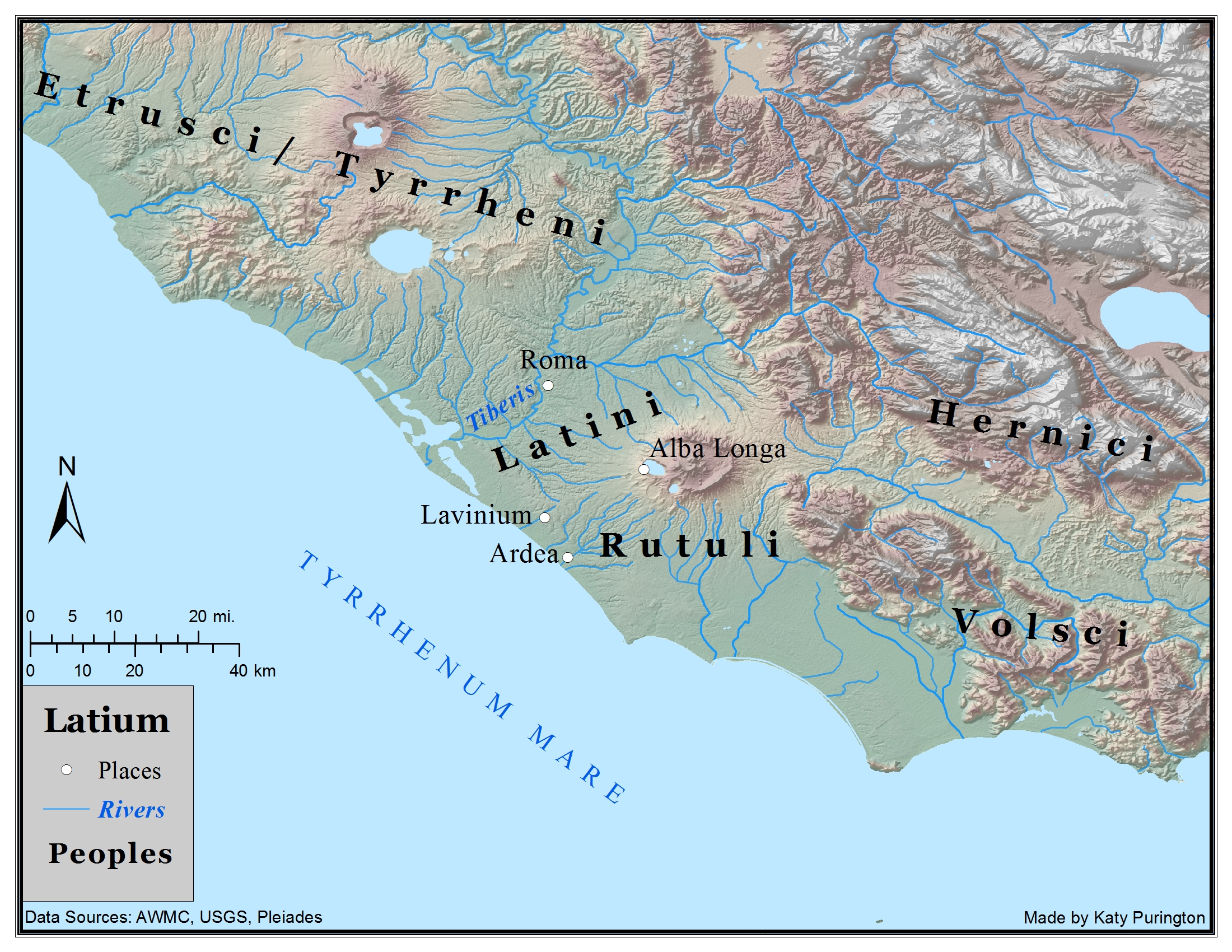
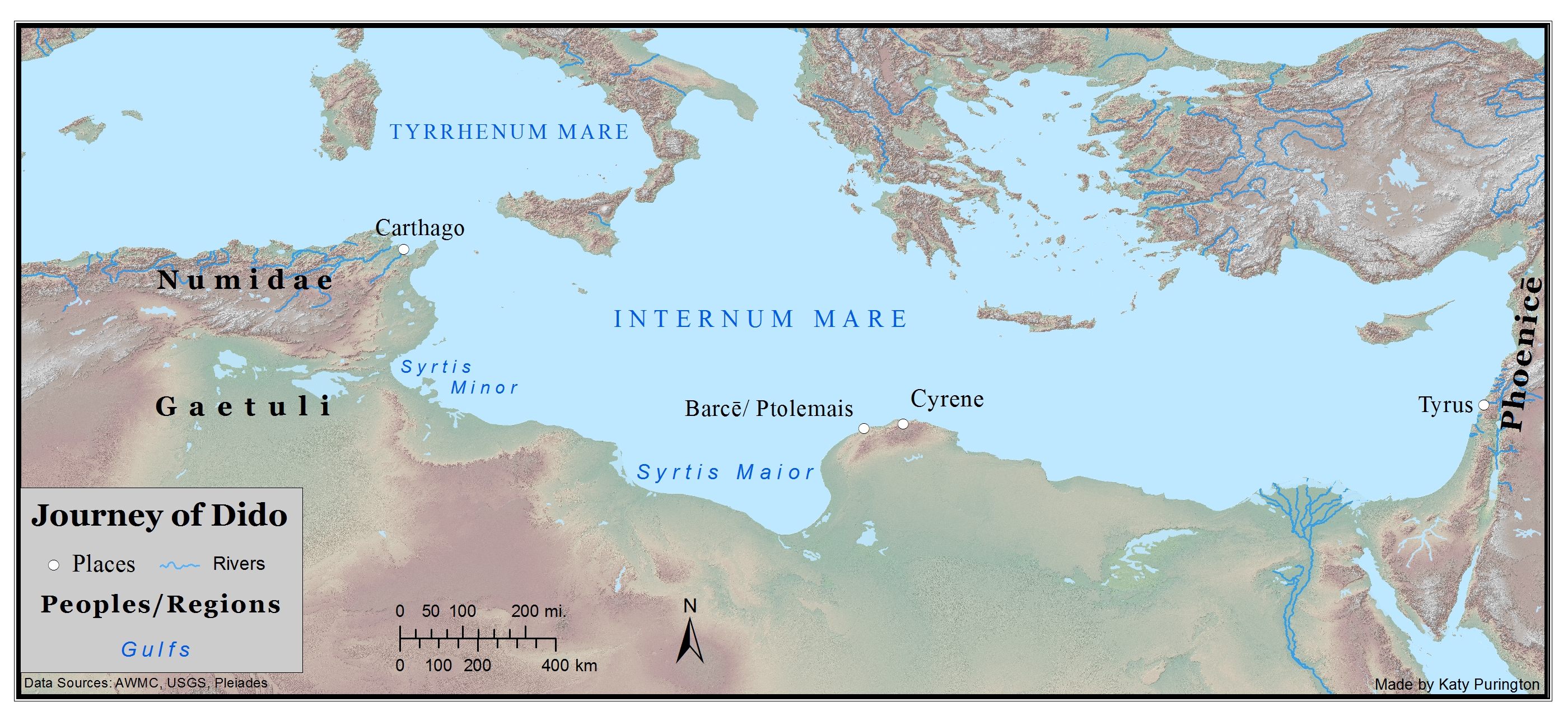
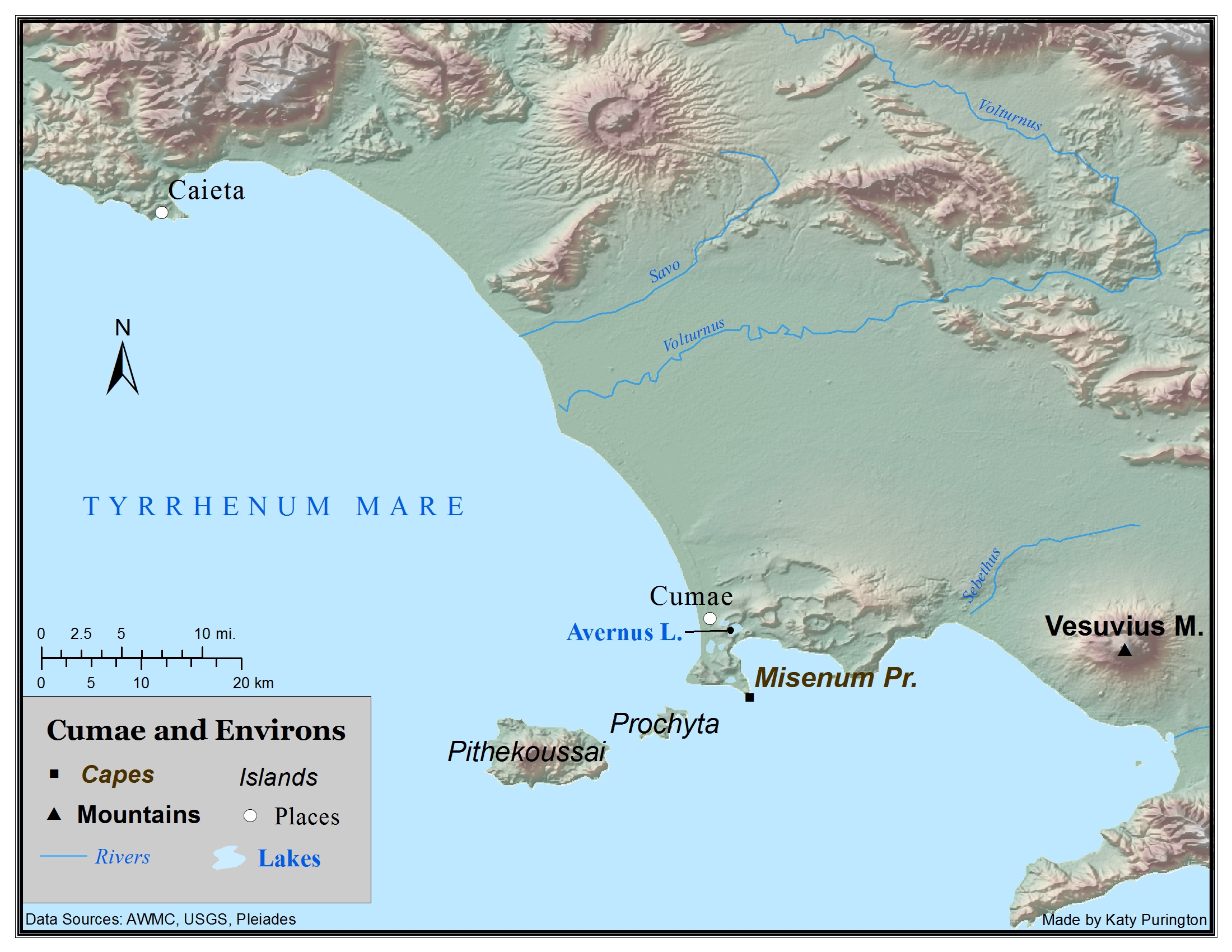
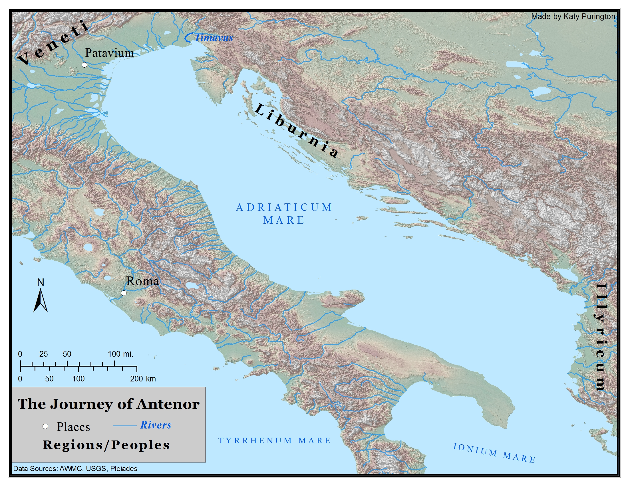
Troy was situated in a strategically valuable piece of land between the Mediterranean Sea and the Black Sea. It was the site of the most famous war in Greek and Roman mythology, the Trojan War. It is the place from which Aeneas starts his journey. Aeneas and a group of Trojans leave the city when the Greeks, enemies of the Trojans, finally breech the walls and sack the city after years of siege warfare. Also known as Ilium and Pergamum.


Ancient coastline and elevation data supplied by the Ancient World Mapping Center.

Comments

Aeneid 2.21-22

Est in cōnspectū Tenedos, nōtissima fāmā

īnsula, dīves opum Priamī dum rēgna manēbant,

Aeneid 2.203-205

Ecce autem geminī ā Tenedō tranquilla per alta

(horrēscō referēns) immēnsīs orbibus anguēs

incumbunt pelagō pariterque ad lītora tendunt;

Aeneid 2.254-256

Et iam Argīva phalānx īnstrūctīs nāvibus ībat

ā Tenedō tacitae per amīca silentia lūnae

lītora nōta petēns, flammās cum rēgia puppis

Type
Map
License
Creative Commons Attribution-NonCommercial-ShareAlike

Latium

Latium as described in Aeneid Book 1, and significant peoples around the region.


Ancient coastline and elevation data supplied by the Ancient World Mapping Center.

Comments

Aeneid 1.1-7

Arma virumque canō, Trōiae quī prīmus ab ōrīs

Ītaliam fātō profugus Lāvīniaque vēnit

lītora, multum ille et terrīs iactātus et altō

vī superum, saevae memorem Iūnōnis ob īram,

multa quoque et bellō passus, dum conderet urbem5

īnferretque deōs Latiō; genus unde Latīnum

Albānīque patrēs atque altae moenia Rōmae.

Aeneid 1.258-259

fāta tibī; cernēs urbem et prōmissa Lavīnī

moenia,

Aeneid 1.269-271

trīgintā magnōs volvendīs mēnsibus orbīs

imperiō explēbit, rēgnumque ab sēde Lavīnī

trānsferet, et Longam multā vī mūniet Albam.

Lavinium:

Alba Longa:

Roma:

Latium:

Type
Map
License
Creative Commons Attribution-NonCommercial-ShareAlike

The Journey of Dido

This map shows Tyre, Dido's homeland, the city from which she was banished.  It also shows Carthage, the city she built for her people, and Barce, the city of King Iarbas, who gave her the land for her city. 


Ancient coastline and elevation data supplied by the Ancient World Mapping Center.

Comments

Aeneid 1.338-341

Pūnica rēgna vidēs, Tyriōs et Agēnoris urbem;

sed fīnēs Libycī, genus intractābile bellō.

Imperium Dīdō Tyriā regit urbe profecta,

germānum fugiēns. 

Aeneid 1.365-368

Dēvēnēre locōs ubi nunc ingentia cernēs

moenia surgentemque novae Karthāginis arcem,

mercātīque solum, factī dē nōmine Byrsam,

taurīnō quantum possent circumdare tergō.

Aeneid 4.35-44

Estō: aegram nūllī quondam flexēre marītī,

nōn Libyae, nōn ante Tyrō; dēspectus Iärbās

ductōrēsque aliī, quōs Āfrica terra triumphīs

dīves alit: placitōne etiam pugnābis amōrī?

Nec venit in mentem quōrum cōnsēderis arvīs?

Hinc Gaetūlae urbēs, genus īnsuperābile bellō,

et Numidae īnfrēnī cingunt et inhospita Syrtis;

hinc dēserta sitī regiō lātēque furentēs

Barcaeī. Quid bella Tyrō surgentia dīcam

germānīque minās?

Syrtis: Syrtis Minor (modern Gulf of Gabès) or Syrtis Maior (modern Gulf of Benghazi) or both (Brill)

Type
Map
License
Creative Commons Attribution-NonCommercial-ShareAlike

Cumae and Environs

Map of Cumae and environs. Cumae is where Aeneas goes to visit his father in the underworld in Aeneid Book 6. The entrance and exit from the underworld are both located around Lake Avernus (Avernus Lacus). Caieta is mentioned by Vergil in Aeneid 6.900-901 as a port named for Aeneas's nurse. 

Ancient coastline and elevation data supplied by the Ancient World Mapping Center.

Comments

Aeneid 6.1-5

Sīc fātur lacrimāns, classīque immittit habēnās

et tandem Euboïcīs Cūmārum adlābitur ōrīs.

Obvertunt pelagō prōrās; tum dente tenācī

ancora fundābat nāvīs et lītora curvae

praetexunt puppēs. 

Aeneid 6.201-204

Inde ubi vēnēre ad faucēs grave olentis Avernī,

tollunt sē celerēs liquidumque per āëra lāpsae

sēdibus optātīs geminā super arbore sīdunt,

discolor unde aurī per rāmōs aura refulsit.

Aeneid  6.232-235

At pius Aenēās ingentī mōle sepulcrum

impōnit suaque arma virō rēmumque tubamque

monte sub āëriō, quī nunc Mīsēnus ab illō

dīcitur aeternumque tenet per saecula nōmen.

Aeneid 6.900-901

Tum sē ad Cāiētae rēctō fert līmite portum.

Ancora dē prōrā iacitur; stant lītore puppēs.

Aeneid 7.1-4

Tu quoque litoribus nostris, Aeneia nutrix,

aeternam moriens famam, Caieta, dedisti;

et nunc seruat honos sedem tuus, ossaque nomen

Hesperia in magna, si qua est ea gloria, signat.


Caieta: a town in Latium. It was situated on a promontory opposite to the city of Formiae, and forms the northern extremity of the extensive bay anciently called the Sinus Caietanus, and still known as the Golfo di Gaeta. (Smith)

Associated Passages
Subjects
Type
Map
License
Creative Commons Attribution-NonCommercial-ShareAlike

The Journey of Antenor

Map of the journey of Antenor as described by Venus in Vergil, Aeneid 1.242-247. Ancient coastline and elevation data supplied by the Ancient World Mapping Center.

Comments

Aeneid 1.242-247

Antēnor potuit mediīs ēlāpsus Achīvīs

Īllyricōs penetrāre sinūs atque intima tūtus

rēgna Liburnōrum et fontem superāre Timāvī,

unde per ōra novem vāstō cum murmure montis

it mare prōruptum et pelagō premit arva sonantī.

Hīc tamen ille urbem Patavī sēdēsque locāvit.

Illyricos sinus: “Illyrian gulfs,” meaning the Adriatic gulf along the shores of Illyricum. Illyrian attacks on shipping brought Roman intervention in the First and Second Illyrian Wars (229/8, 219 BC).

regna Liburnorum: "the realm of the Liburni." A wild and piratical race (Livy 10.2), the Liburni used privateers called lembi or naves Liburnicae with one very large lateen sail, which, adopted by the Romans in their struggle with Carthage (Eutropius 2.22) and in the Second Macedonian War (Livy 42.48), supplanted gradually the high-bulwarked galleys which had formerly been in use. (Caesar, Civil War 3.5; Horace, Epodes 1.1.) (Smith)

fontem Timavi: the small river Timavus (modern Timavo) flows into the Adriatic near Trieste.

urbem Patavi: meaning Padua, some twenty miles west of Venice. According to a tradition recorded by Virgil, and universally received in antiquity, it was founded by Antenor, who escaped thither after the fall of Troy; and Livy, himself a native of the city, confirms this tradition, though he does not mention the name of Patavium, but describes the whole nation of the Veneti as having migrated to this part of Italy under the guidance of Antenor. it was at an early period an opulent and flourishing city: Strabo even tells us that it could send into the field an army of 120,000 men, but this is evidently an exaggeration, and probably refers to the whole nation of the Veneti, of which it was the capital. (Strab. v. p.213.) Whatever was the origin of the Veneti, there seems no doubt they were, a people far more advanced in civilisation than the neighbouring Gauls, with whom they were on terms of almost continual hostility. (Smith)

Associated Passages
Subjects
Type
Map
License
Creative Commons Attribution-NonCommercial-ShareAlike