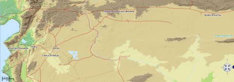
Latin namedescriptionAntiochiaCapital city of the province of Syria and the residence of Jerome intermittently in the 370s. He was ordained there in the late 370s by Bishop Paulinus. Founded near the end of the fourth century BC by Seleucus I Nicator, one of Alexander the Great's generals, it eventually rivaled Alexandria as the chief city of the Near East. After the founding of Constantinople, it ceased to be the principal city of the East. At the same time, it began to be prominent as a Christian city, ranking as a Patriarchal see with Constantinople and Alexandria. With the former of these cities it was connected by the great road through Asia Minor, and with the latter, by the coast road through Caesarea. Ten councils were held at Antioch between the years 252 and 380.NisibisBirthplace of Malchus. Situated on the Roman-Persian frontier in very rich and fruitful country, Nisibis was long the center of a very extensive trade, and the great northern emporium for the merchandise of the East and West. In the fourth century control of this strategic and heavily fortified border city passed back and forth between the Roman and Sassanid Persian empires. The Persians ceded it to the Romans in 299. From 360 to 363, Nisibis was the camp of Legio I Parthica. In 363 Nisibis went back to the Persians after the defeat of Emperor Julian. PersisPersis or “Persia” refers at this period to the Sassanian Empire, the last kingdom of the Persian Empire before the rise of Islam, and a major strategic rival of the Roman Empire. When Malchus leaves home to become a monk he cannot go east from Nisibis, “because of the proximity of Persia and the Roman military guard” on the militarized frontier (3.2). Named after the House of Sasan, the Sassanid dynasty ruled from 224 to 651 AD, and was at this time under the control of the long-reigning and dynamic Shapur II (AD 309–379).ChalcisSite of Malchus’ monastery, mod. Qinnasrin. An important caravan stop on the frontier zone with the Syrian desert, Chaclis had a fine Roman road leading to Antioch, and was in late antiquity an important center of Syriac Christianity.Immasa small settlement about 20 miles due east of AntiochBeroeaThe second largest Syrian city after Antioch, modern Aleppo. Edessamodern Şanliurfa in Turkey, also known as Urfa, about 200 miles NE of Beroea (modern Aleppo). The public highway from Antioch via Beroea and Edessa to Nisibis was a major travel and trade route connecting the Mediterranean with Mesopotamia. The emperor Septimius Severus had a road built along this route in AD 197 when he prepared a campaign against the Persians (Gray).fluviusGray identifies this as the river Jhagjhaga (Greek: Mydgonius or Hirmus), which flows past Nisibis, now in in SE TurkeyRoad from Antioch to Nisibis via Beroea and EdessaThe public highway from Antioch via Beroea and Edessa to Nisibis was a major travel and trade route connecting the Mediterranean with Mesopotamia. The emperor Septimius Severus had a road built along this route in AD 197 when he prepared a campaign against the Persians (Gray).
License
Creative Commons Attribution-ShareAlike


This map was created using Antiquity À-la-carte, a web-based GIS interface and interactive digital atlas for creating custom maps of the ancient world using accurate ancient geographical features, an initiative at the Ancient World Mapping center. Placemarkes come from the Pleiades Project. It is meant to accompany William Turpin's DCC edition of Jerome's Life of Malchus the Captive Monk (2019). Annotations are based on various sources, inlcuding the edition of the Life of Malchus by Christa Gray (2015), and Smith's Dictionary of Greek and Roman Geography (1854).