BG 1

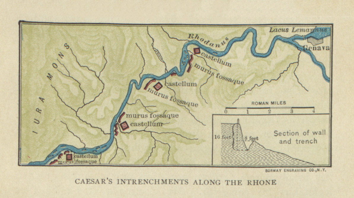
Map: Caesar's Intrenchments along the Rhone by A.L. Hodges

    Map of the defenses Caesar established along the Rhone river to stop the Helvetian migration (Caesar's Gallic War 1.8). From A.L. Hodges, Caesar: The Gallic War (New York: The Macmillan Company, 1910), p. 59.

    Type
    Map
    License
    Creative Commons Attribution-ShareAlike
    Agent
    Date
    1909
    article Nav

    Map: Campaign of 58 BC by A.L. Hodges

      Map of the events of 58 BC, during which Caesar stopped the Helvetian migration and put down Ariovistus and the Germans (Caaesar's Gallic War Book 1). From A.L. Hodges, Caesar: The Gallic War (New York: The Macmillan Company, 1910), p. 55.

      Type
      Map
      License
      Creative Commons Attribution-ShareAlike
      Agent
      Date
      1909
      article Nav

      Map: Defeat of the Helvetii by A. Von Kampen

        Map of the final battle between Caesar and the Helvetians, ending their migration attempt (Caesar's Gallic War 1.23-26). From J.B. Greenough, B.L. D’ooge and M.G. Daniell, Caesar’s Gallic War (Boston: Ginn & Company, 1898), p. 23. 

        Type
        Map
        License
        Creative Commons Attribution-ShareAlike
        Date
        1898
        article Nav

        Map of Helvetia by Raimund Oehler

          Map of the territory of the Helvetii, who attempted to migrate to another land (Caesar's Gallic War 1.2). From J.B. Greenough, B.L. D’ooge and M.G. Daniell, Caesar’s Gallic War (Boston: Ginn & Company, 1898), p. 5.

          Associated Passages
          Type
          Map
          License
          Creative Commons Attribution-ShareAlike
          Date
          1898
          article Nav

          Map: Campaign of 58 BC by Greenough, D'ooge, and Daniell

            Map of the arena of Caesar's campaign of 58 BC, during which he stopped the Helvetian migration and fought Ariovistus (Caesar's Gallic War Book 1). From J.B. Greenough, B.L. D’ooge and M.G. Daniell, Caesar’s Gallic War (Boston: Ginn & Company, 1898), p. 1.

            Type
            Map
            License
            Creative Commons Attribution-ShareAlike
            Date
            1898
            article Nav

            Campaign Map for Book 1.30-54 by Arthur Tappan Walker

              Map of the arena of the campaign against Ariovistus (Caesar's Gallic War 1.30-54). Brown shows territory that was already under Roman control when Caesar received the province, red states that Caesar conquered, and blue states that submitted to Caesar without fighting. From Arthur Tappan Walker, Caesar's Gallic War (Chicago: Scott, Foresman and Co. 1907), p. 117. 

              Type
              Map
              License
              Creative Commons Attribution-ShareAlike
              Date
              1907
              article Nav

              Map: Field of Battle of Caesar and Ariovistus by Eugene Stoffel

                Map of the final battle between Caesar and Ariovistus, bringing the German invasion of Gaul to an end (Caesar's Gallic War 1.51-53). From Eugene Stoffel, Guerre de Cesar et d’Arioviste et Premieres Operations de Cesar en l’an 702 (Paris: Imprimerie Nationale, 1890) plate 2.

                Type
                Map
                License
                Creative Commons Attribution-ShareAlike
                Date
                1890
                article Nav

                General Map of the War with Ariovistus by Eugene Stoffel

                  Map of the arena of the war with Ariovistus and the Germans (Caesar's Gallic War 1.31). From Eugene Stoffel, Guerre de Cesar et d’Arioviste et Premieres Operations de Cesar en l’an 702 (Paris: Imprimerie Nationale, 1890) plate 1.

                  Type
                  Map
                  License
                  Creative Commons Attribution-ShareAlike
                  Date
                  1890
                  article Nav

                  Map: the Mound of Plettig by Eugene Stoffel

                    Map of the mound of Plettig, a likely location of the meeting between Caesar and Ariovistus (Caesar's Gallic War 1.43-46). From Eugene Stoffel, Guerre de Cesar et d’Arioviste et Premieres Operations de Cesar en l’an 702 (Paris: Imprimerie Nationale, 1890) p. 56.

                    Type
                    Map
                    License
                    Creative Commons Attribution-ShareAlike
                    Date
                    1890
                    article Nav

                    Map of Vesontio by Eugene Stoffel

                      Map of the town of Vesontio and its natural fortifications (Caesar's Gallic War 1.38). From Eugene Stoffel, Guerre de Cesar et d’Arioviste et Premieres Operations de Cesar en l’an 702 (Paris: Imprimerie Nationale, 1890) p. 48.

                      Type
                      Map
                      License
                      Creative Commons Attribution-ShareAlike
                      Date
                      1890
                      Subscribe to BG 1