Eugene Stoffel

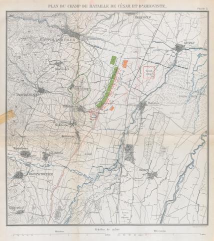
Map: Field of Battle of Caesar and Ariovistus by Eugene Stoffel

    Map of the final battle between Caesar and Ariovistus, bringing the German invasion of Gaul to an end (Caesar's Gallic War 1.51-53). From Eugene Stoffel, Guerre de Cesar et d’Arioviste et Premieres Operations de Cesar en l’an 702 (Paris: Imprimerie Nationale, 1890) plate 2.

    Type
    Map
    License
    Creative Commons Attribution-ShareAlike
    Date
    1890
    article Nav

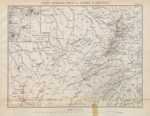
    General Map of the War with Ariovistus by Eugene Stoffel

      Map of the arena of the war with Ariovistus and the Germans (Caesar's Gallic War 1.31). From Eugene Stoffel, Guerre de Cesar et d’Arioviste et Premieres Operations de Cesar en l’an 702 (Paris: Imprimerie Nationale, 1890) plate 1.

      Type
      Map
      License
      Creative Commons Attribution-ShareAlike
      Date
      1890
      article Nav

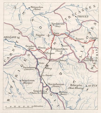
      Map: Theatre of the First Operations of Caesar in 51 BC by Eugene Stoffel

        Map of the arena of the campaign against Vercingetorix and the Gallic alliance (Caesar's Gallic War 7.1-2). From Eugene Stoffel, Guerre de Cesar et d’Arioviste et Premieres Operations de Cesar en l’an 702 (Paris: Imprimerie Nationale, 1890) p. 145.

        Type
        Map
        License
        Creative Commons Attribution-ShareAlike
        Date
        1890
        article Nav

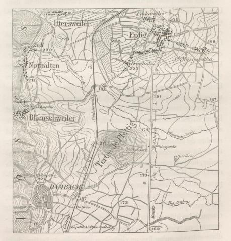
        Map: the Mound of Plettig by Eugene Stoffel

          Map of the mound of Plettig, a likely location of the meeting between Caesar and Ariovistus (Caesar's Gallic War 1.43-46). From Eugene Stoffel, Guerre de Cesar et d’Arioviste et Premieres Operations de Cesar en l’an 702 (Paris: Imprimerie Nationale, 1890) p. 56.

          Type
          Map
          License
          Creative Commons Attribution-ShareAlike
          Date
          1890
          article Nav

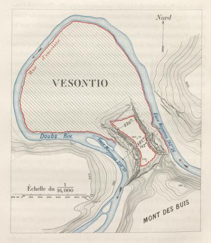
          Map of Vesontio by Eugene Stoffel

            Map of the town of Vesontio and its natural fortifications (Caesar's Gallic War 1.38). From Eugene Stoffel, Guerre de Cesar et d’Arioviste et Premieres Operations de Cesar en l’an 702 (Paris: Imprimerie Nationale, 1890) p. 48.

            Type
            Map
            License
            Creative Commons Attribution-ShareAlike
            Date
            1890

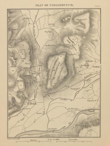
            Map of Uxellodunum by Eugene Stoffel

              Map of Uxellodunum, a town taken by hostile Gauls (Caesar's Gallic War 8.32). From Napoleon III, History of Julius Caesar Volume 2 (New York: Harper & Brothers, 1866), plate 31. 

              Type
              Map
              License
              Creative Commons Attribution-ShareAlike
              Date
              1866
              article Nav

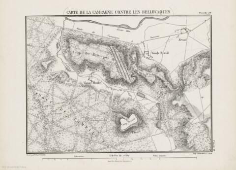
              Map: Campaign against the Bellovaci by Eugene Stoffel

                Map of the site of battle between the Romans and the Bellovaci (Caesar's Gallic War 8.14-16). From Napoleon III, History of Julius Caesar Volume 2 (New York: Harper & Brothers, 1866), plate 29.  

                Type
                Map
                License
                Creative Commons Attribution-ShareAlike
                Date
                1866
                article Nav

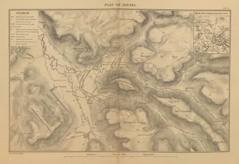
                Map of Alesia by Eugene Stoffel

                  Map of the stronghold of Alesia, the final battle between Caesar and Vercingetorix (Caesar's Gallic War 7.69). From Napoleon III, History of Julius Caesar Volume 2 (New York: Harper & Brothers, 1866), plate 25.

                  Type
                  Map
                  License
                  Creative Commons Attribution-ShareAlike
                  Date
                  1866
                  article Nav

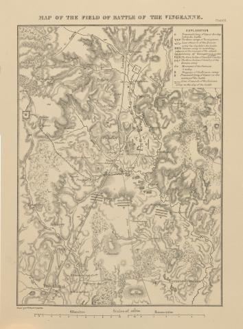
                  Map: Field of Battle of the Vingeanne by Eugene Stoffel

                    Map of the site of a battle between Vercingetorix and Caesar on the way to Alesia (Caesar's Gallic War 7.67). The site is a conjecture from Stoffel based on topographical and textual hints. From Napoleon III, History of Julius Caesar Volume 2 (New York: Harper & Brothers, 1866), plate 24. 

                    Type
                    Map
                    License
                    Creative Commons Attribution-ShareAlike
                    Date
                    1866
                    article Nav

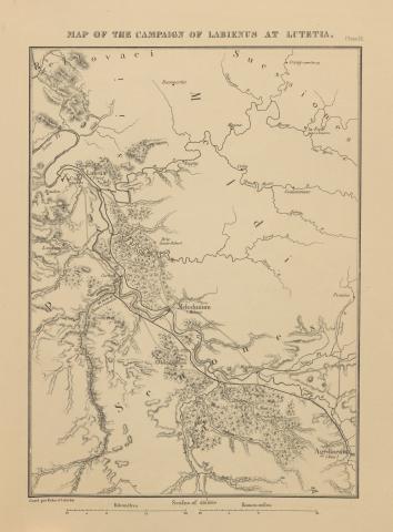
                    Map: Campaign of Labienus at Lutetia by Eugene Stoffel

                      Map of Labienus' journey to Lutetia (Caesar's Gallic War 7.57). From Napoleon III, History of Julius Caesar Volume 2 (New York: Harper & Brothers, 1866), plate 23.

                      Type
                      Map
                      License
                      Creative Commons Attribution-ShareAlike
                      Date
                      1866
                      article Nav
                      Subscribe to Eugene Stoffel